Spooky Snapshots
Happy Halloween from the Snapshot Wisconsin team! We wanted to share a few of our favorite spooky photos that have been captured on our project’s trail cameras. We hope you enjoy them, and that everyone has a fun and safe Halloween!
Note: Some photos include animals carrying dead prey.

A bobcat from Vilas County arching its back

A coyote and what appears to be either a full moon or a light spot in the sky.

An unknown light in front of the camera lens. Speculations include a spider web or insect.

An Unidentified Flying Object hovering over this raccoon in Dane County.

A coyote carrying a scavenged deer head.

A flock of red-winged blackbirds soars across a field.
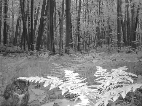
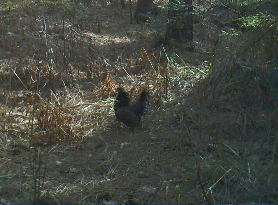
An ominous great horned owl staring into the distance.
Expanding Citizen Science Horizons
The following piece was written by OAS Communications Specialist Rachel Fancsali for the Snapshot Wisconsin newsletter. To subscribe to the newsletter, visit this link.
If you are interested in branching out as a volunteer scientist, there are plenty of other opportunities to explore. The Snapshot Wisconsin team wanted to highlight some of the other exciting programs that our volunteers and their loved ones may be interested in. After all, volunteer scientists play an important role in more than just wildlife research.
The state of Wisconsin has a long history of volunteer science programs. The DNR has an extensive list of its own volunteer science programs and partner projects, including programs like the Wisconsin Bumble Bee Brigade and the Wisconsin Rare Plant Monitoring Program.
But what about programs outside of Wisconsin? There are plenty of national programs available on a wide variety of topics. If you are looking for something new to dip your toes in, check out these other programs:
Community Collaborative Rain, Hail And Snow Network (CocoRaHS)
- A community-based volunteer network of weather observers working together to measure and map precipitation (rain, hail and snow) in their local communities.
- CocoRaHS data is used by meteorologists, hydrologists, teachers, engineers and organizations such as the National Weather Service and the USDA.
- Visit the Wisconsin chapter of CocoRaHS.
FrogWatch USA
- Volunteers report the calls of local frogs and toads heard during evenings from February to August, depending on the area and peak breeding season for local species. The data are then loaded into a public database, similar to Snapshot Wisconsin’s Data Dashboard.
- Partnered with the Citizen Science Academy (hosted by the Chicago Botanic Garden) and the National Geographic Society, FrogWatch USA data is used to help develop practical strategies for conserving frog and toad species.
- Visit FrogWatch USA to learn more.
NASA NeMO-Net
- Map Earth’s oceans in this videogame that trains an artificial intelligence for a NASA supercomputer using FluidCam’s 3D images of the seafloor, the first instrument that can see through waves.
- Players identify coral reefs, other shallow marine environments and marine animals using 2D satellite and drone images and 3D reconstructions of underwater environments. Player classifications are used to teach the convolutional neural network (CNN) called NeMO-Net and help scientists better understand and protect coral reefs globally.
- To dive in, visit NASA NeMo-Net.
The Secchi Dip-In
- Operated by the North American Lake Management Society, this program collects water clarity measurements from rivers, lakes and estuaries to track water quality changes across the continent. Over the past 20 years, the database has accumulated more than 41,000 records on over 7,000 individual waterbodies.
- Volunteers are taught how to take water clarity measurements primarily using a Secchi disk unless the water body is a river or stream that would require a turbidity tube or black disk. Data is primarily collected in July, but the program does accept data year-round!
- Visit the Secchi Dip-In project site, then spend a day on the lake.
We certainly appreciate our volunteers at Snapshot Wisconsin, and we know these programs also appreciate their volunteers. Whether you want to expand your citizen science portfolio into finding collection water samples, listening to frog songs or teaching an AI, there are plenty of options. Have fun exploring!
From Langlade County, Wisconsin to Zurich, Switzerland
The following piece was written by OAS Communications Specialist Rachel Fancsali for the Snapshot Wisconsin newsletter. To subscribe to the newsletter, visit this link.
You now know that Snapshot Wisconsin has contributed to important research not only statewide, but also nationwide with Snapshot USA. But did you know that over the past year and half, Snapshot Wisconsin has been contributing to an international collaborative art exhibit?
One Snapshot volunteer took on the challenge of running a special camera trap to contribute to the University of Zurich Graduate Campus’s Triggered by Motion project. The project will be creating an immersive, walk-through pavilion where visitors will be able to experience the biodiversity of wildlife from 14 countries around the world, and video footage of north woods Wisconsin wildlife will be on display for the world to see!
Connecting Science, Art, and the Public
The University of Zurich (UZH) Graduate Campus focuses on engaging with the public through events and exhibitions, utilizing its cross-faculty platform to create collaborative exhibitions that connect science, art and the public. The project Triggered by Motion is one of several collaboration projects that will be featured in the overarching Planet Digital exhibition, which explores the digital transformation of our world.
In the field of wildlife research, trail cameras are an excellent example of digital transformation in research. As many Snapshot volunteers already know, trail cameras are a non-invasive method, allowing a glimpse of wildlife behind the scenes. The goal of the Triggered by Motion project is to give a unique perspective on how researchers use camera traps to learn about the world, bringing the audience closer to this research method.
Each trail camera video for the project will condense a year’s worth of footage into a 20-minute time-lapse. Then the videos will be synchronized, so that daylight will slowly move from one screen to the other, circling around the pavilion to imitate the rotation of the earth.
In June 2020, UZH was referred to Snapshot Wisconsin. At the time, there was another trail camera in southern California, but UZH was looking to diversify its North American captures. The teams from UZH and Snapshot Wisconsin were able to connect and discuss the possibility of Snapshot Wisconsin participating in the international project.
Snapshot Wisconsin checked all the boxes for Triggered by Motion: it’s a well-established project, located in the northern half of the U.S. and operates year-round. Also, the cameras that Snapshot uses normally take still photos that fulfill the project’s data needs, but they are capable of capturing video footage. What really set Snapshot Wisconsin apart from other Triggered by Motion participants is our program’s applied research focus, with Snapshot data contributing to wildlife decision support.
With that, Snapshot Wisconsin became a part of the Triggered by Motion project. Now it was up to the Snapshot team to find a volunteer and set the modified camera.

Finding a Volunteer and a Camera Site
When it came time to choose a Snapshot volunteer to work with UZH, volunteer coordinator Claire Viellieux knew just the right person. “I met Blayne Zeise at the last in-person volunteer recognition event in 2019, and he has a good record of checking cameras and uploading in a timely manner,” Viellieux said.
After talking with Viellieux, Blayne Zeise was happy to help. “I had actually asked her at the volunteer event about adding another camera anyways,” Zeise said.
Zeise had already been running his own personal trail cameras on public lands for a couple of years before joining the Snapshot Wisconsin program in 2018. “I started out with a couple of $30 cameras from Walmart and started using them on public lands, then worked my way up from there,” Zeise said. He heard about Snapshot Wisconsin through some of Snapshot’s yearly advertising and decided to give it a try. “I thought it would be nice to have a better-quality camera with a lockbox on it, especially on public land,” Zeise said.
Zeise is very familiar with several public lands in the Marathon and southern Langlade County areas. His own cameras have been monitoring wildlife by river crossings on the Red River in Langlade County and Plover River in Marathon County. Zeise monitors his Snapshot Wisconsin camera in a fishery area just south of Antigo in Langlade County.
This familiarity with the landscape was a huge factor in Zeise’s decision on where to put the camera. “It’s mostly birds and deer at the river crossings,” says Zeise, “but there’s a larger diversity of animals at the other site [the fishery area].”
However, while biodiversity of the location was a large factor, it wasn’t the only one. Zeise knew that he may have to check batteries more often with capturing video footage, making it imperative that the location is easily accessible in all seasons. “The location I picked is a short hike, and there is still a lot of animals that pass through there,” Zeise said.
A Rough Start
Unfortunately, right off the bat, there were some roadblocks to deployment.
When setting up a Snapshot camera for filming at the office, Viellieux noticed the camera couldn’t meet the criteria set by UZH. To avoid motion blur and distortion once on the big screen exhibit, the video footage needed to be captured in 60 full frames per second with a 1920 x 1080 resolution. The Snapshot Wisconsin cameras, suitable for Snapshot Wisconsin’s research objectives that uses a large photo database, were not designed to meet that high of criteria for filming. Zeise tried one of his own personal cameras as well, but also had no luck.
UZH staff still wanted Zeise and Snapshot Wisconsin to be a part of the project, so they purchased and mailed a camera for Zeise to set up. After a small setback getting the UZH camera to film at appropriate times, Zeise’s next challenge was monitoring the camera’s battery pack with the extra demand filming had on battery life. “It just sucks up so much energy doing 30 second video every half hour during the day, and 15 second video at night,” said Zeise.
Most other Triggered by Motion trap sites were using solar packs to power the cameras. Zeise’s concern with this solution was how easy it would be for someone to walk off with the solar pack, especially being located on public lands. For most of the year, it was not difficult at the fishery area to change the rechargeable batteries that most Snapshot Wisconsin cameras use. With the rechargeable batteries, Zeise had to change them every three days.
Zeise’s main battery challenge would be in the north woods’ snowy and bitter winters; changing the rechargeable batteries every three days, or more frequently because of the cold, was not going to be efficient. He made the switch to lithium batteries, which meant changing batteries every two weeks. “Better than trudging through the snow!” Zeise joked.
Once the weather warmed back up, Zeise switched back to the rechargeable batteries. The system worked well for the year that Zeise collected data.

Capturing the Best of Wisconsin Wildlife
Zeise’s decision to record at the fishery area was spot on. A large variety of species were seen in the video clips including bear, bobcat, foxes, deer, coyotes and more. Zeise also saw a few neat interactions between species, such as the apparent squabble between a ruffed grouse and a pileated woodpecker (see screen capture below). UZH would also occasionally ask Zeise to confirm what animal was captured. “One time they asked me, ‘what are those really blue colored birds?’, said Zeise. “They were blue jays! I guess they don’t have them over there [in Switzerland].”
What Zeise found most interesting about using video is being able to see how animals used the area. “I was really surprised by how much the deer relied on that area for browsing,” Zeise said. “I even asked Emily [at Snapshot] if there was a way to ID the plants that the deer were using. She recommended a plant ID app, and I was able to ID species such as black ash, bitternut hickory, and black walnut.”
Operating a different kind of camera also brought new findings. “I was kind of surprised with the video that the coyotes were not spooked by it. With some of the Snapshot Wisconsin cameras, they hear the click and just about jump out of their skin,” Zeise observed.
The UZH camera, a Bushnell Dual Core No-Glow, is designed to remain inconspicuous. “They call it a no-glow, but it’s really like a hard black plastic filter to help hide the infrared. The coyotes and foxes probably see it, but the deer may not,” said Zeise.

What Now?
With the completion of data collection, UZH was able to construct the exhibit. The project ended with 22 camera traps in 14 countries around the world, enlisting the help of 29 researchers and seven citizen-scientists to monitor the traps. The Triggered by Motion project is at the very center of the Planet Digital exhibition, and the physical exhibition premiered Feb. 11, 2022 at Museum für Gestaltung Zürich. The exhibition will stay at the museum until June, when it will be packed up and shown across the world. The dates and locations of the traveling exhibit are still to be determined.
However, a digital publication of the entire Planet Digital exhibition is available, and the Triggered by Motion project page can be viewed here.
Hopefully, the exhibit will make its way to the U.S. at some point, and we can walk through Snapshot Wisconsin and Zeise’s contribution to an international project! “If it travels to the U.S., I would definitely like to go see it in person,” said Zeise. “I think that was one of the coolest parts, just to be a part of a big project, with three locations in the U.S and over 20 worldwide.”
“I get to keep the camera too,” Zeise said, “It’s a pretty sweet deal.” Zeise mentioned he already has plans for the camera, including deploying it at one of the river crossings he monitors. There’s a spot where a lot of blue heron hang out, and he wants to capture that action.
The Snapshot team is honored to have played a part in connecting Zeise with this international project, and we are lucky to have great volunteers, willing to go beyond just hosting a Snapshot camera.
A big thank you goes to Blayne Zeise for all his help and really taking the reins on monitoring an extra special camera!
View the entire Planet Digital exhibition here.
A National Collaboration Releases Their First Publication
The following piece was written by OAS Communications Coordinator Ryan Bower for the Snapshot Wisconsin newsletter. To subscribe to the newsletter, visit this link.
For the last three years, Snapshot Wisconsin has been contributing to a similar citizen science program called Snapshot USA, and Snapshot USA recently reached an important milestone worth celebrating. They released their first publication! Congratulations, Snapshot USA!
In honor of Snapshot USA reaching this milestone, the Snapshot Wisconsin team wanted to highlight this fellow citizen science project and share with our volunteers a lesser-known way that Snapshot Wisconsin data is being used.
What is Snapshot USA?
Snapshot USA is a national effort to bring together trail camera data from across the country and learn about what drives the distribution of mammal species within the United States. Snapshot USA takes a similar approach to Snapshot Wisconsin, having people classify trail camera photos to generate usable data for science. The main differences are that Snapshot USA is a nationwide effort and is focused entirely on mammals.
Snapshot USA was organized in 2019 by scientists from the North Carolina Museum of Natural Sciences and the Smithsonian Conservation Biology Institute. They asked fellow researchers, citizen science programs (including Snapshot Wisconsin) and private citizens to upload and classify their trail camera photos. Much to everyone’s excitement, over 150 people and programs participated in the effort.
Better yet, people contributed photos from 110 locations across all 50 states, proving that there are people all over this country who value efforts like Snapshot USA and Snapshot Wisconsin.
Snapshot Wisconsin’s Contributions
For our part, the Snapshot Wisconsin program was thrilled to support a fellow citizen science project. We submitted data from 2019 and 2020, and we are working on submitting data from this last year as well. It is important to us to support other programs like Snapshot USA and build up science together.
Every year, Snapshot Wisconsin has contributed data from around 10 of our trail cameras in the Clam Lake elk camera grid. Snapshot USA required at least ten cameras clustered within a 5km area, so only a few areas of our camera grid like the elk camera grids met the requirement.
Despite limitations in which cameras we could include, the Snapshot Wisconsin team is glad that we were able to contribute to this effort at all. Jennifer Stenglein, one of Snapshot Wisconsin’s lead scientists, said, “Snapshot Wisconsin is not set up to have areas with clustered cameras. We made a special exception for the elk grid because the data are used to monitor the growing elk herds across the state. Fortunately, the elk grid matched the minimum requirements to participate.”
Stenglein also mentioned how important it was to her personally that Snapshot Wisconsin contributed to this nationwide effort. “As a scientist, having open data is huge. There is so much trail camera data out there, but it’s [isolated] to specific programs or people. Snapshot USA created a place for trail camera data to come together and be available. That allows scientists to ask questions we couldn’t before, like how climate change is impacting species at a national level.” Stenglein is excited to see what other researchers do with the compiled data.

How Snapshot USA Operates
In addition to sampling populations from across a wider scale than Snapshot Wisconsin, Snapshot USA samples from all major habitats and development zones found within the United States. When a new collaborator joins the program, they select the combination of setting (Urban, Suburban, Rural, Wild, Other) and habitat (Forest, Grassland, Desert, Alpine, Beach, Anthropogenic, Other) that matches their camera site.
Our volunteers may notice that some of these site combinations differ from what Snapshot Wisconsin uses. For example, urban deployment does not fit Snapshot Wisconsin’s criteria for setting up a camera. Stenglein thought that the addition of urban areas adds an interesting element to the dataset, but it shows a fundamental difference in what Snapshot Wisconsin and Snapshot USA are trying to capture.
Next, collaborators upload their photos from a specified time window. In 2019, Snapshot USA collected photos from the 14-week period from August to November. Once uploaded, collaborators could start classifying photos, similarly to how our camera hosts do it.
One important difference is that Snapshot USA puts all their photos through a second round of classification – this time by an expert. Expert review happens within Snapshot Wisconsin as well, but only for the species we’ve learned are classified with lower accuracy. Our accuracy analyses have shown that volunteers do a great job of accurately classifying most species, especially the most common species, so Snapshot Wisconsin only expertly classifies the photos of the hard-to-classify species and rare species. Besides, Snapshot Wisconsin would not be able to expertly classify its 60+ million photos. However, this extra step is possible for a program like Snapshot USA.
“Limiting the time window for data collection is really common in trail camera studies,” said Stenglein. “I don’t know if there is any perfect time window for Snapshot USA to choose, since you will always miss something. However, it does make sense for them to select a window of time. It would be too challenging to collect a whole year’s worth of data, let alone have an expert review.”
Once both rounds of classifications are done, the data are assembled into a package and prepped for release in the form of a new publication. This type of publication is called a “data paper” because its main purpose is to release a new dataset for others to work with.
“It’s a cool, new trend in science for data papers to come out,” said Stenglein. “I’ve seen more effort being put towards proper archiving of data. Researchers can use these datasets to test their own hypotheses and come up with new and exciting insights into wildlife distributions in the USA. I think this is where research needs to be, so it’s encouraging to see this trend.”

2019 Data Is Released
In April 2021, Snapshot USA officially published their 2019 dataset. The paper was published in the scientific journal Ecology and had around 100 different authors.
In total, the dataset included photos from 1,509 cameras across 110 locations, and all 50 states and the District of Columbia contributed data. The dataset had 166,036 observations (photos) and found 83 unique mammal species. Seventeen bird species were also detected, which impressed Stenglein, but the project wasn’t looking for birds, only mammals.
“All together, that’s an impressive number of species detected,” said Stenglein. “Trail cameras aren’t set up to see all species equally. Birds, for example, often spend most of their time above the line of sight of cameras, so capturing 17 species of birds is pretty cool.”
Snapshot Wisconsin’s contributions included sightings of just over 20 of the 83 mammal species found by Snapshot USA. Given the small area that the photos came from, seeing 20 species is a healthy number. If we were able to use more of the grid, that number would have been much higher.
The paper reported that the three most detected species nationwide were white-tailed deer, squirrels and raccoons, in that order. Snapshot Wisconsin’s own data visualization tool, the Data Dashboard, also shows a similar trend, with white-tailed deer and squirrels being the top two species detected in Wisconsin. Racoons weren’t third, but they are high on the list.
Coyotes were the most widespread species detected across the nation, which surprised some of the Snapshot Wisconsin team. However, Stenglein explained, “It may be because there is only one major species of coyote. Deer and other common animals change species as you go across the country. Mule deer, white-tailed deer and black-tailed deer each have different ranges across the U.S.”
What’s Next?
Stenglein was proud of the Snapshot USA team for pulling this effort together. As one of the main researchers for Snapshot Wisconsin, Stenglein knows how much work it is to collect photos from hundreds of sources and extract usable data from them. Stenglein mentioned that it is great to see another citizen science project release their first publication. “Our Snapshot Wisconsin team only has so much capacity to work on decision-support tools, so it is cool to know that these data will be used in more ways and by more people.”
Stenglein also mentioned that there is a second publication in the works already. This publication will release the 2020 dataset. It’s nice to see such a quick turn around time for the second publication.
“The peer review process can easily take months to years,” explained Stenglein, “so there will always be a lag. However, I expect that this first lag will be the biggest. I’ve already seen process improvements on the data uploading side. They’ve moved to a more efficient process, which really helps.”
Stenglein believes Snapshot USA has expanded its data collection to Europe as well for the 2021 season, which could offer some interesting comparisons for researchers.
Stenglein’s final thoughts for the Snapshot USA program were:
“I’m so impressed that they pulled this off. We know from Snapshot Wisconsin how difficult it can be to keep things running smoothly, especially when it comes to IT infrastructure and solutions. I wish Snapshot USA all the luck as they continue to expand their program, and I look forward to working with them each year. What you’ve accomplished is impressive. Remember that.”
Submit a Caption for Snapshot Photos!
The following piece was written by OAS Communications Coordinator Ryan Bower for the Snapshot Wisconsin newsletter. To subscribe to the newsletter, visit this link.
Jessica Knackert, one of the newest Snapshot team members, recently added a new discussion called “Funny Photo Captions” to the Zooniverse Talk Board. This discussion contains funny trail camera photos for volunteers to add their own captions. Take a look as Zooniverse volunteers have already contributed several entertaining captions.
For those who don’t know, Zooniverse is a platform that is used by citizen science projects to expand their reach to a wider community of volunteers. Snapshot Wisconsin uses Zooniverse to draw a consensus classification about trail camera photos, while also involving people from all over the world.
Zooniverse’s Talk Board feature allows volunteers to share photos, get second opinions and meet fellow volunteers. The talk board is also one of the easiest ways for volunteers to connect with the larger volunteer community.
Within the new talk board, volunteers can add photos to four categories that the Snapshot program frequently sees: Animal Selfies, Comical Situations, Interactions and Animal Yoga.
Knackert is excited to provide another space for volunteers to connect.
“Our volunteers were already captioning photos themselves, but they didn’t have a central place for it. I think this board is a great place for volunteers to come and enjoy the humor of their fellow volunteers,” said Knackert.
Volunteers were eager to use this new talk board adding captions to photos within its first day of being live.
To keep the fun going, Knackert has added a new batch of photos for people to caption. Plus, volunteers can make their own posts on the talk board with photos they find. There is plenty of fun to be had.
Captions can be funny, silly or clever. However, the team asks that all photos adhere to community standards. Moderators and staff will remove posts that contain spam or language that violates these standards. To meet standards, all posts must be appropriate for all ages and be respectful of the other volunteers who use the talk board. Also, please do not expose personal information of other users, including names or addresses, without their permission.
Now, let’s get to the fun part – seeing some of the captions that volunteers have already posted. Please note that we couldn’t include captions in their entirety here; visit the talk board to read the full caption. The team appreciates submitted captions and the smiles they brought.

Animal Selfies
The team knew they wanted to include Animal Selfies as one of the categories of funny photos. Snapshot trail cameras are designed to be as quiet and inconspicuous as possible, but animals inevitably get curious. That curiosity leads them to approach the camera and accidentally take a selfie. The team has used several of these selfies in the program newsletter over the years, but new ones come in regularly.
The photo above was posted in the Animal Selfies sub-thread on Zooniverse, and the team chose three captions that made them laugh. We hope you enjoy these volunteer-made captions and feel inspired to add your own to the Animal Selfie post on the talk board.
Caption from Goldfinch33:
“So…you’ve seen this property, we’ve flown around it, you’re happy with the tree heights…can we close this deal?
~said The Bluebird of Avian Real Estate
Caption from bzeise:
I’m blue, da ba dee da ba di WHOAH! What was that?
Caption from sbreich:
Are you looking at me? ARE YOU LOOKING AT ME??
Comical Situations
The second category within the funny photos talk board covers the silly activities we see animals doing in photos. Whether it is slipping on ice or hanging upside down from a branch, these photos capture some entertaining moments that make us laugh. The “levitating” animal photos from the previous article also belong in this category.
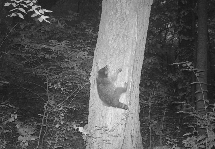
The photo of a raccoon barely clinging to a tree (above) was added to the Comical Situations sub-thread and generated some entertaining captions. Here are a few captions submitted by volunteers. If you can think of more captions, don’t forget to add them!
Caption from momsabina:
But he double-dared me….
Caption from charleysangel:
Help! Now what?
Caption from AndyC3339:
Alex Honnold, [a famous rock climber,] made it look so easy!

Interactions
If you look at which photos are shared the most on Zooniverse’s Talk Board, fun interactions are always high on the list. Interactions can be between two members of the same species, or they can be interactions between different species. In fact, these photos are so commonly shared that there is a searchable tag (multi_species) that volunteers can use to see photos of multi-species interactions.
The photo of a mother black bear and her cub, playing in the grass was added to the Interactions sub-threaad. Of the three captions, which one is your favorite?
Caption from Megeth:
When I say “roll over” you need to roll. Ready? Roll!
Caption from Swamp-eye:
Mama down, Papa help me up
Caption from charleysangel:
How many paws am I holding up? Wrong

Yoga Poses
The last category of funny Snapshot photos is Yoga Poses. Cat Pose, Downward Dog Pose, Crow Pose, Cobra Pose and Camel Pose are all named after animals, so it shouldn’t be surprising that we captured some animals stretching in yoga poses.
This type of photo was already covered a year and a half ago on Zooniverse, but there wasn’t an opportunity to caption these photos. The team wanted to bring these photos back for captioning fun. Don’t forget to add your own captions to the Yoga Pose post on the Zooniverse Talk Board.
Caption from Megeth:
“You put your right leg out and you shake it all about”
Caption from bzeise:
Am I doing this planking thing right?
Caption from Goldfinch33:
What?! I do this every morning when I wake up. My mentor told me “stretching exercises every morning without fail keeps joints supple.” Do I move like I’m 9?
Knackert’s Hope For The Talk Board
Knackert thanks everyone who added a caption already and encourages all Snapshot volunteers to join in the fun.
“My hope for this caption board is that it draws in a part of our volunteer community that has never checked out or even knows about Zooniverse. A lot of our volunteers host cameras and only ever classify their own photos. They only get to see the cool photos that they find. I’d love to see those existing volunteers head over to Zooniverse and join in on the conversations happening there.”
If you want to add captions to any of the photos, head over to the Zooniverse Talk Boards and check them out here.
From Testing Cameras in Her Backyard to a Statewide Monitoring Program
The following piece was written by OAS Communications Coordinator Ryan Bower for the Snapshot Wisconsin newsletter. To subscribe to the newsletter, visit this link.
Jen Stenglein, Quantitative Research Scientist at the Wisconsin DNR and one of the longest-serving Snapshot staff members, walks us through the early years of the program and how Snapshot Wisconsin expanded into the massive project that it is today.
If you are a newer Snapshot volunteer, then here is your chance to learn more about the program’s early history. For those who lived much of the history firsthand (especially the early adopters), this article might be a trip down memory lane. Either way, we hope you get something from this recounting of the past and connect more strongly with the program.
A Grant and a Collaboration
Snapshot Wisconsin’s origin stems from a NASA grant that the University of Wisconsin-Madison received in 2013. The grant aimed to lay the groundwork for a citizen science program for monitoring wildlife that would be launched by the Wisconsin Department of Natural Resources (DNR). Soon after, the DNR created Snapshot Wisconsin and started what would become a massive project.
Stenglein got involved while the project was still in the planning phase. “I was finishing my PhD at the time in Madison, WI and heard about the project. Thanks to my connection with the university, I already knew many of the major players involved,” said Stenglein. “Some of the initial project planning happened before I came in, so the project was basically waiting for someone to figure out the logistics.”
What cameras should volunteers use? How should the cameras be set up to capture the best photos? How would they get equipment to volunteers and train them? There were many questions and fewer answers.

2014: Figuring out the Logistics
In 2014, Stenglein began to answer these questions by running tests in her backyard. “I had a whole line of cameras set up in my backyard, each a different model. We also had cameras out behind the DNR building [to test a second location]. There were so many questions we needed to answer,” recalled Stenglein.
At the time, the Snapshot team was comprised of only two people: Stenglein and Christine Anhalt-Depies, the current project coordinator for Snapshot Wisconsin. Stenglein was working on the program full-time, while Anhalt-Depies was devoting half her time to support Snapshot Wisconsin. Piece by piece, they ran tests and figured out what cameras and setup the first volunteers would use.
Stenglein recalled figuring out other logistics too like where the cameras would go. “I remember looking at a map of Wisconsin and making the decision to divide townships into quarters. That would be our grid setup,” said Stenglein. “Those grid blocks were about the right size [roughly nine square miles] for what we wanted and left space for over 6,000 cameras around the state. That sounded like a doable maximum.”
By the end of the year, Stenglein and Anhalt-Depies had finished enough of the equipment testing to put their plan to the test, starting with Wisconsin’s elk herd.
2015: The First True Test
Elk at the time were just being reintroduced in Wisconsin. There was one small, existing elk population (reintroduced from Michigan), but that population hadn’t taken off how people hoped. A second effort was being set up to bring Kentucky elk to Wisconsin, and those elk were coming in just as Snapshot became ready to test out their program.
“We thought it would be a really great opportunity to test Snapshot Wisconsin on a known population. All of the elk were radio-collared, [so we knew how many were being added to the area.] It was a perfect test to see how well our equipment and methods would hold up,” said Stenglein.
But of course, things didn’t go perfectly as planned. One near miss stood out to Stenglein and captured some of the hecticness of getting the program up and running.
“We almost didn’t have the cameras in time,” explained Stenglein. The camera delivery came in late on the same day that we were scheduled to set up the cameras. “We already had folks waiting in the field, and I had to plead with the delivery driver [to prioritize delivering our cameras].” There were some near misses like that, but Stenglein said they worked through them all in the end.
By the end of the year, a few hundred cameras had been deployed across the elk zones, and the program was officially running. Volunteers now ran the cameras, and images were starting to stream in.

2016: Expanding the Program
Once the team felt they were in a solid routine, they started thinking about expanding Snapshot to more of the state. “It was nice to have the elk grid up and running already, because we knew how the logistics would function,” said Stenglein.
The Snapshot team focused on recruiting educators, even seeking out a couple grants to build collaborations with different educator groups. “Educators seemed like a good place to start, because they affect so many people in their daily life,” said Stenglein. “They could help us reach more people faster.”
To start, the team mainly accepted volunteers from only two Wisconsin counties: Sawyer and Iowa Counties. “We heard from lots of people [around the state] who were excitedly awaiting enrollment, but we wanted to roll things out slowly [to work out any new kinks in the process]. For example, we didn’t want to have a bunch of people getting equipment, only to be frustrated by the IT system not working properly yet,” said Stenglein.
Stenglein and the team were enrolling volunteers at a steady pace, but volunteers had to attend an in-person training session before they received their equipment. Since the team was still only three to four people, there were a limited number of trainings offered. That bottleneck kept the expansion to a manageable pace.
The project was going well though. By the end of 2016, Snapshot had expanded to nine counties (adding Iron, Jackson, Manitowoc, Waupaca, Dodge, Racine and Vernon Counties). The IT infrastructure was working properly, supporting the in-flow of data. All of the planning that Stenglein and the team did was starting to pay off.
The team even launched their first first season of photos on Zooniverse, the crowd-sourcing platform. “Zooniverse was just an itty-bitty platform back then,” joked Stenglein, “but it helped us process photos much faster than we could have without it.”
2017: Growth and Rare Species Detections
Just as 2016 saw a growth to nine counties accepting volunteers, 2017 saw a similar growth. By the end of the year, one quarter of the state’s counties, or 18 in total, were accepting volunteers. St. Croix, Oneida, Marinette, Clark, Dane, Grant, Marathon, Rusk and Taylor counties were all added to the list in 2017. Additionally, over 1,000 volunteers had joined the program by this point, and the program was accepting volunteers even faster than before.
Coverage of the state was starting to fill in enough to be useful from a data perspective. For example, the Snapshot program saw its first rare species detection in 2017. It was a moose from Price County. “I remember it was really exciting because we were waiting for a rare species,” said Stenglein. The team quickly saw more rare species detections in rapid succession too, including a marten and whooping crane. “That whooping crane was extra exciting because we could ID the individual [from the colored bands on its legs] and learn more about it,” added Stenglein.

2018: Gearing up for a Statewide Launch
Up until early-2018, the Snapshot team was adding counties to spread out coverage across the state. However, by March 2018, there were 26 counties involved. “At that point, adding counties was getting arbitrary,” said Stenglein. “Most areas of the state had at least one county involved already.” It was time to start accepting volunteers from all 72 counties: a true statewide launch.
Many improvements to the team and infrastructure had smoothed out most of the kinks in the system. The team had grown in size, and that additional capacity helped speed up onboarding of new volunteers. A new version of the cameras was also being used, which took fewer blank photos, and training had moved online to cut down on staff travel times. Everything was giving a green light for launch.
On August 9th, Snapshot Wisconsin officially launched statewide. Stenglein said the statewide launch was when it felt like Snapshot truly hit its stride. “I really felt like that point in time was pivotal for the project.”
Immediately after the statewide launch, the size of the program exploded. The team was able to accept much of the backlog of volunteers that had previously been unable to join the program. In 2018 alone, over 1,200 volunteers and 1,174 new trail cameras were added to the project, almost doubling Snapshot’s size.
2019: More Staff and a Slew of Publications
To compensate for the doubling of the volunteer base, four new Snapshot positions were added to the team, and Anhalt-Depies took over as the project coordinator. The added support was very timely because the program continued to expand as more and more volunteers joined.
Additionally, enough data had come in by this point that the team (especially Stenglein) could start publishing their findings.
The program had already been generating data for the management of certain species, including generating fawn-to-doe ratios for deer and population estimates for each elk herd. However, until 2019, the project hadn’t published any peer-reviewed publications.
In a flurry, five scholarly publications were released in 2019 by the Snapshot Wisconsin team or one of the graduate students working with the program. Five publications in a single year is substantial, but it meant something extra to the Snapshot team.
“It was great to [finally] show the work we’d done on the data side of Snapshot,” said Stenglein. “In some ways, it took longer than we expected, because we thought that we’d have stuff to share right away. However, Snapshot’s value is the accumulation of data and the time series we’ve built up over the years, so it was appropriate that it took some time to get to the first publication.”
2020: An Important Year for Snapshot
2020 was a weird but important year for Snapshot. According to Stenglein, the team didn’t slow down much in 2020. In fact, many important milestones happened this year. The first of which was a huge boom of activity on Zooniverse.
People suddenly had more free time than usual, and many people used that time to classify photos on Zooniverse. Snapshot Wisconsin’s page saw substantially more users (and specifically new users) than normal. No surprise that photos were being classified faster as well. In fact, the team even had to adjust staff responsibilities to make sure there were photos on the platform. What a great problem to have, right?
Another exciting change during 2020 was the release of the Snapshot Wisconsin Data Dashboard, an interactive tool that lets the public play with Snapshot data. Anyone could explore the data of 19 Wisconsin species and see where (and when) each species was detected.
Stenglein said that releasing a product like the Data Dashboard had been the plan from the beginning, but the team didn’t originally know what form it would take. “Open data has been an important goal of the project, especially because of our collaboration with NASA and the University of Wisconsin.” It just took time to figure out what form the product would take and to make sure the data were accurate enough.
Most of our volunteers will know that Snapshot Wisconsin also reached a total of 50 million photos near the end of 2020. That is an impressive amount of data to receive and process. According to Stenglein, this milestone meant that Snapshot was finally a “big project.”
“It meant that we had the data that we wanted, and everything was working. There was a big sense of accomplishment, and for me, it meant that all that planning had paid off,” said Stenglein.
The fact that so many milestones happened in 2020 speaks to the sustained efforts of our volunteer base. Stenglein said, “The volunteers totally rallied and continued to bring the data in. That kept the project going. The fact that volunteers kept checking their cameras and classifying photos was big for us. Thank you.”
Reflecting on the Past
As the end of 2021 inches closer, the team reflected on where they’ve come as a program since Stenglein’s backyard experiments in 2014. They remember the near-miss with the elk cameras and the statewide launch in 2018. They remember the first rare species detection and the release of the first public-facing data visualization product, the Data Dashboard.
It has taken a lot of work to get to this point, both from our staff and our volunteers. The team wants to thanks its volunteers for their contributions over the years, whether you just joined or have been with us since the beginning. Every classification matters, just as all of our volunteers matter to us. Thank you for seven years of excitement and support!
Highlighting Sandhill Cranes on the Data Dashboard
The following piece was written by OAS Communications Coordinator Ryan Bower for the Snapshot Wisconsin newsletter. To subscribe to the newsletter, visit this link.
Continuing with the bird theme, the Snapshot Team wanted to highlight one of the five specific species that can be chosen while classifying photos: the sandhill crane. At the same time, the team wanted to use the new 2020 data on the Data Dashboard, so they decided to do both!
The team invited fellow DNR researcher, Jess Jaworski, Assistant Waterfowl Research Scientist within the Office of Applied Science, to look through the sandhill crane data on the Data Dashboard. Jaworski is currently working on waterfowl research, but she previously worked with cranes.
Jaworski’s graduate research involved studying the nesting behaviors of cranes in Wisconsin. “My graduate research was focused on the nest success of the reintroduced whooping crane population at the Necedah National Wildlife Refuge. The majority of my work was monitoring incubation behaviors of both whooping cranes and sandhill cranes under duress of an avian-specific black fly. This fly caused a wide-spread and synchronous abandonment of nests.” Jaworski put up several trail cameras at nests and went through thousands of photos to monitor behaviors at those nests; Not that different from what Snapshot Wisconsin does.

A Bit Of Background On Sandhill Cranes
Before we dive in, let’s make sure everyone knows a bit about sandhill cranes. Jaworski was happy to share her knowledge of sandhill crane behavior.
Wisconsin’s sandhill cranes are part of the Eastern population of migratory sandhill cranes, and there are over 70,000 individuals in this population. As implied by the term “migratory,” they don’t spend the entire year in Wisconsin. Jaworski explained that these birds spend the winter down South. Around mid-March, they come back north to their breeding grounds and establish pair bonds.
Sandhill cranes are typically a monogamous species, so they will find a mate and pair off if they don’t already have one. “They usually try to find a pair bond within up to two years of birth, and they start nesting at three to six years in open marsh wetlands, although sandhill cranes can nest in a wide variety of habitats. They hopefully will hatch within a 28-day incubation period and fledge their young within two to three months. Once that is done [usually in September/October], they migrate back to their wintering grounds.” Come the next March, they start the cycle over again.

Diving In To The Data Dashboard
Jaworski was curious how well the trail camera data would match the description she gave above. The team sat down with her to see. At first glance, Jaworski said the data seemed pretty consistent with what she knows about their behaviors and where cameras were located around the state.
Take the map of detections by county, for example. Jaworski pointed out a higher percentage of crane detections in the southeast quadrant of the state. “That is consistent with their habitat [preferences]. They typically nest in open marshes, and the map matches where I know wetlands exist in the state,” said Jaworski. “Dodge County has cranes in the Horicon Wetland Area, for example. To the northwest, there are more cameras picking up these birds, potentially from the Crex Meadow Area. There is a large amount of birds in Adams County nearby to Juneau County where birds nest at the Necedah National Wildlife Refuge, which is where I did my graduate work.”
Jaworski also looked at detections by the ecological landscape, a clickable option to the left of the map. Instead of counties, the map is blocked out into 16 regions with unique ecological attributes and management opportunities. “Generally, the southern and eastern sections of the state have more open, wetland areas, so I’m not surprised there are more detections in those areas. There are also a lot of agricultural fields here too,” said Jaworski.
“Sandhill cranes can adapt easily to human-made landscapes like agricultural fields, and it isn’t uncommon to see them nesting in smaller wetlands near agricultural fields, for example. If there are a lot of cameras in these areas, then there will be more sightings of sandhill crane.” In contrast, the northern part of the state tends to be more forested land, so the southeast is the ideal habitat for a crane looking to build a nest.

Activity By Month And Hour Of The Day
So far, the detection locations matched what Jaworski expected to see, but one of the more interesting features of the dashboard is the breakdown of detections by month and by hour of the day. How well would the data hold up?
Jaworski started with the month data and immediately zeroed in on the lull in detections during the winter months. “This is exactly what I’d expect to see,” said Jaworski. “These migratory cranes are down south in their winter grounds [during these months]. When you get to March and April, I see a heightened activity pattern from cranes migrating back and nesting. Then, there is a lull again later in the year, as they start migrating back south.”
Jaworski also noticed that the migration south occurs over a much longer period of time than the migration back, as seen by a more gradual decline in detections in September and October. “That could be a product of different nest initiation times or different successes/failures throughout the nesting period. If birds nested earlier, then they will have fledged their young earlier than others and potentially leave the state sooner.” Alternatively, pairs who failed to successfully rear a fledgling may start over again if there is time. These pairs wouldn’t be able to migrate as early as pairs who succeeded on their first try, and that may lead to more detections later in the year.
The Snapshot team discussed how the placement of cameras also can influence the detection of species like the sandhill crane. Not all species spend their time in areas that are easy for trail cameras to watch. Not many Snapshot cameras overlook the center of a lake or marsh, which can lead to biases in detections for certain species.
However, Jaworski did confirm that cameras set up near-ideal nesting habitats will be much more likely to detect cranes. Cranes can be seen while they are up and about from their nests, looking for food, or when adults swap who is incubating their nest.
Jaworski also looked at sandhill crane activity throughout the day. “In the morning hours, they will leave their roosting areas. When pairs are forming pair bonds, they will do dawn unison calls. You can often hear them in the early morning hours, [and the calls are quite distinct]. Throughout the day, they are probably feeding and moving about the wetland, so detections are more common then. In the evening, they return to their roosting site for the night.”
All in all, there were pretty clear patterns in the activity graph, and those patterns match what Jaworski expected to see. There is a small amount of variation between the hours of the daytime, but Jaworski didn’t think those peaks and valleys represented any meaningful behaviors for sandhill cranes. Jaworski said, “It is hard to determine fine-tuned patterns throughout the day. It could simply be from a bias in where the cameras are placed.”

The 2020 Data Are Accurate And Consistent
Jaworski and the Snapshot team adjusted the date slider in the left-most column of the dashboard to look at only the 2020 data. The 2020 data showed all of the same patterns that we’ve already mentioned and is consistent with what we know about where cranes are distributed across the state. “It shows that there is nothing unusual about this past year that indicated sandhill cranes are moving from their range or aren’t where you would normally see them occur,” said Jaworski.
Jaworski played around with the date slider some more and looked at each of the other years’ data individually. She noticed that the number of detections increased each year, starting from 2017. “It is really cool that detections are increasing. It says that interest in the program is also increasing,” said Jaworski. “Snapshot’s expansion each year provides more information about where these birds are located. Each year, you will find more detections, which helps inform research for this species. I also really like that there is a record of that data so that we can go back and analyze it if any questions arise in future studies.”
Jaworski’s Parting Thoughts
Before everyone parted ways, Jaworski shared some final thoughts with the team about the program and its impact.
“It’s wonderful that a program like Snapshot exists. If somebody is interested in knowing what is going on with a particular species, it is awesome that Snapshot allows people to find that information through the Data Dashboard. It is a great opportunity for people to get involved.
Additionally, that type of cooperation between researchers and those who aren’t in research is invaluable and helps inform [our] research. Its great from a research perspective and a curiosity perspective when we collaborate.
Plus, getting involved [in citizen science] can spark an interest in a science career! A lot of us in research didn’t initially start out that way. Many of us started out as citizens who observed something interesting or maybe as kids who tagged along with our parents while they were doing outdoor activities. Looking at species or finding out what a scientist did inspired us.
My family comes from a natural resource background. My dad started out as a forester, and my mom worked as a park ranger and a boating officer in New Mexico. I tagged along with my mom quite often when she was giving presentations at the nature center. We were outside recreating a lot, camping and fishing. It had a big influence on my life and my career choice.”
Jaworski encouraged more people to check out the Data Dashboard and learn something new about one of the species available. The Snapshot team suggests looking at the data in a similar way to how Jaworski did, piece by piece and thinking about what a species might be up to in different areas and at different times. It is a great way to think about the lives of these species. Plus, with the addition of the 2020 data, there is more data than ever to look at.
Using Snapshot’s Bird Photos in New Ways
The following piece was written by OAS Communications Coordinator Ryan Bower for the Snapshot Wisconsin newsletter. To subscribe to the newsletter, visit this link.
A male American woodcock stretches his wings skyward in a courtship display, a great-horned owl strikes an unknown target on the forest floor and a male northern cardinal duteously feeds his newly fledged young.
These are moments in the lives of birds captured by Snapshot Wisconsin trail camera photos. Until recently, however, many of these avian images were hidden within the Snapshot Wisconsin dataset, waiting to be uncovered by a team of bird enthusiasts. Unlike how they normally watch birds, from behind a pair of binoculars, this time they were behind a keyboard.
When Snapshot volunteers classify an image, they normally can choose from a list of around 40 wildlife species. Only five of these species are among Wisconsin’s 250 regular bird species: wild turkey, ruffed grouse, ring-necked pheasant, sandhill crane, and the endangered whooping crane. These five species are options on the list because they either are of special management interest within the Wisconsin DNR or are easier to detect by Snapshot Wisconsin cameras.
The rest of the bird photos are classified into a catchall group, called “Other Bird.” Until recently, the “Other Bird” images were considered incidental images, but the increasing size of this category caught the attention of the Snapshot Wisconsin team. In fact, “Other Bird” is the second most common classification of the six bird categories, only second to Wild Turkey (Figure 1, Panel A), which comprises over a quarter of all bird photos.
The team reached out to the Wisconsin DNR’s Bureau of Natural Heritage Conservation (NHC) to brainstorm ideas on how to leverage the “Other Bird” dataset, which had amassed 150,000 images at the time and was still growing.

Planting A Seed Of Collaboration
During their discussion with the NHC, the idea was brought up that these “Other Bird” images could contribute to the Wisconsin Breeding Bird Atlas II (WBBA II). The WBBA II is an enormous, multi-year field survey to document breeding birds and their distribution across the state. Information like the frequency of breeding and which areas birds are breeding in help the DNR see changes in breeding status for many bird species. This information can also be compared to data from the previous survey (from 1995 to 2000) and sets a benchmark for future comparisons as well.
The current survey uses data collected from between 2015 and 2019. Coincidentally, the earliest Snapshot images are from 2015 as well, so the dates of the survey aligned quite well. This collaboration seemed like a good fit.
However, there are some important differences between data collected from birding in the field and from images captured by Snapshot trail cameras. For example, many birds spend much of their time in the canopy, outside the camera’s field of view. Additionally, birders often use sound cues to identify signs of breeding in the field. Trail camera images do not contain these types of breeding cues. Lastly, certain breeding behaviors can be too fleeting to observe from a set of three images.
The team wasn’t sure yet if the trail camera photos would truly contribute much to the WBBA II.

A Collaboration Was Born
Members of the Snapshot Wisconsin and NHC teams ran a test of the “Other Bird” photos. They reviewed a small, random subset of images and learned that many of the birds could be identified down to the species level. The teams also found enough evidence of breeding, such as sightings in a suitable habitat (for breeding) or the presence of recently fledged young. Both teams decided to go ahead with the collaboration and see what they could find.
The full dataset was sent to a special iteration of Zooniverse, called the Snapshot Wisconsin Bird Edition, and birders began classifying. All of the “Other Bird” images were classified down to the species level, as well as assigning a breeding code to each image. In just over a year, the large collection of bird photos was classified, thanks to some dedicated volunteers.
The NHC’s Breeding Bird Atlas Coordinator, Nicholas Anich, extracted these new records and added them to the WBBA II. The atlas utilizes a statewide survey block system that is based on a preexisting grid from the United States Geological Survey. The survey block system requires that certain blocks be thoroughly surveyed in order for the atlas to have adequate statewide coverage, and many of the new Snapshot data points contributed to these priority survey blocks. Anich said, “[The Snapshot data] will be valuable information for the WBBA II, and we even discovered a few big surprise species, [such as] Spruce Grouse, Western Kingbird, and Whooping Cranes.”
In addition to these rare species, many of the high-value classifications were what Anich described as breeding code “upgrades.” The observed species already had been recorded in a given block, but the photos showed stronger evidence of breeding than had previously been reported. For example, an adult of a given species may have already been spotted in the area during the breeding season, but a photo showed a courtship display. The courtship display is stronger proof of breeding in the area than a single adult sighting.
How Useful Were the Snapshot Photos?
Both the (in-person) birding efforts and the trail camera photos picked up species that the other did not, so both approaches brought different strengths to the table.
One of the strengths of the trail cameras was that they are round-the-clock observers, able to pick up certain species that the in-person birding efforts missed. Anich said he noticed that nocturnal species (American Woodcock and Barred Owl) and galliforms (Wild Turkey, Ruffed Grouse) were more common in the Snapshot dataset than reported by the birders in the field, in certain areas at least. “Running into gamebirds was a bit the luck of the draw,” Anich said.
Both Anich and the Snapshot team agreed that the trail cameras were best used in conjunction with in-person surveys, rather than a substitute for each other because they each observed a different collection of species.

Insights Into The “Other Bird” Category
As a bonus for anyone who is interested in this project, the Snapshot team analyzed the photos classified for the WBBA II and created an infographic of the orders and families included. The photos included were captured between 2015 and 2019.
An immediate trend the team saw was that many of the birds were from species with larger body sizes, ground-dwelling species and species that spend time near or on the ground. For example, Anseriformes (ducks and geese) and Pelecaniformes (herons and pelicans) are the second and third most common order in the “Other Bird” category. The next most observed groups include woodpeckers, hawks, eagles, owls and shorebirds. While these birds may not spend all of their time near the ground, food sources for these species are often found in the stratum, an area where most trail cameras are oriented.
It was interesting that the most common order (comprising over half of the “Other Bird” classifications) was from the bird order Passeriformes (perching birds or songbirds). This order does not initially appear to fit the trend of ground-dwelling or larger-bodied birds. However, closer inspection revealed that the most common families in this order did fit the trend. For example, Turdidae (thrushes, especially American Robins), Corvidae (crows, ravens and jays) and Icteridae (blackbirds and grackles) comprised much higher percentage of the photos than any other families.
Thanks To Everyone Who Helped Classify Bird Photos On Zooniverse!
Overall, the Snapshot Wisconsin Bird Edition project was a huge success. In total, 154 distinct bird species were identified by nearly 200 volunteers, and over 194,000 classifications were made. The Snapshot Wisconsin and WBBA II teams extend a huge thank you to the Zooniverse volunteers who contributed their time and expertise to this project. The team was happy to see such strong support from the Wisconsin birding community, as well as from around the globe.
If you weren’t able to help with this special project, stay tuned for other unique opportunities to get involved as Snapshot continues to grow and use its data in new ways. If you contributed to the project, reach out to the Snapshot team and let them know what your favorite species to classify was.
The 2020 Data Are Now Available on the Data Dashboard
The following piece was written by OAS Communications Coordinator Ryan Bower for the Snapshot Wisconsin newsletter. To subscribe to the newsletter, visit this link.
The Snapshot Team is happy to announce that the data from 2020 are now available on the Data Dashboard. Explore the 2020 dataset yourself today!
Snapshot’s Data Dashboard is a data visualization tool that lets the public interact with the data collected from over 2,000 trail cameras spread across the state. The Data Dashboard first was made available to the public in October 2020 and showcased the data of 18 species. Since then, an additional species have been added to the list, and the Snapshot Team plans to add more over time.
One of the unique features of the dashboard is that it lets people choose which data they want to visualize. You can look at data from individual years by selecting the desired date range on the slider along the left side of the dashboard. Four distinct years (2017-2020) are available to peruse. When a new date range is selected, the map of Wisconsin will update and show only the data for the selected dates, allowing anyone to see trends over time.
Check out the 2020 data on Snapshot Wisconsin’s Data Dashboard:
https://widnr-snapshotwisconsin.shinyapps.io/DataDashboard
Volunteer Highlight- River Bend Nature Center in Racine County
The following piece was written by OAS Communications Coordinator Ryan Bower for the Snapshot Wisconsin newsletter. To subscribe to the newsletter, visit this link.
Snapshot Wisconsin volunteers have been asking to hear about unique ways others engage with the program. Today, the Snapshot Wisconsin team highlights, not an individual, but a group that manages one of the longer-running Snapshot trail cameras – River Bend Nature Center (RBNC) in Racine County.
RBNC is an outdoor environmental education center that leases and manages about 80 acres of upland and lowland forest, as well as a six-acre prairie, from the county. River Bend’s primary mission is environmental education, conservation and sustainability with a variety of programs for all ages, ranging from little tikes to seniors.
Christa Trushinsky, Naturalist and Director of Education at RBNC, has worked at the nature center since 2016 and oversees their Snapshot trail camera. “I went to grad school for Environmental Conservation, so I’m very interested in exactly what Snapshot Wisconsin does, looking at the dynamics of land and the species that use it,” said Trushinsky. Trushinsky first heard about the program from a Snapshot Wisconsin team member she went to graduate school with and got in touch with her to learn more.
Little did Trushinsky know, that connection would later play a role in developing many of the nature center’s programs.

River Bend Nature Center, Racine County, Spring 2021
A Good Fit for River Bend Nature Center
River Bend has been hosting a trail camera for four years now and has found some intriguing ways to incorporate Snapshot photos into their teaching. “Snapshot Wisconsin is such a crucial tool for what we are trying to do here, especially for species that are elusive or nocturnal,” said Trushinsky.
Trushinsky said they often use Snapshot photos in their Skulls, Skins, and Scat program to help kids identify species that they wouldn’t normally be able to see. “Since some animals are nocturnal or very elusive, we can use the images to prove that these animals are out there [in the forest] and using the landscape,” explained Trushinsky. “Seeing proof of these animals in the neighboring forest makes them real to the kids in a special way. The animals are more than
something they see on TV – they are real and nearby.”
The trail camera pictures also act as a segue to the hands-on portion of the program, where participants look for animals and signs of animals (e.g. nests, burrows and tracks). “If we find an animal that can be handled, we talk to the kids about how to do so gently and appropriately,” said Trushinsky. Sometimes the children interact with an animal for the first time, such as feeling a slug’s sliminess or a snake’s scaliness. “That’s all part of it, showing them how to handle wildlife appropriately, as well as which to respect and stay away from.”
RBNC incorporates Snapshot pictures in other ways as well. Staff have introduced the concept of predator-prey relationships to children by showing time-lapse photos of predators tracking their prey. Trushinsky recalled an example of a doe walking by the camera, and a minute later, a coyote followed closely behind. Trushinsky uses Snapshot photos to start discussions about different relationship dynamics between the species seen on the camera.
Trushinsky has also taken Snapshot images off-site and given presentations at schools and colleges. To highlight examples of camouflage, she shows participants sets of pictures from the trail camera and asks them if they can figure out where the animal is and identify it. “Basically, I introduce it as, ‘Hey, this is Snapshot Wisconsin. You guys could be doing this on your property!’ I talk about what [species] we see at River Bend and take them through the process of classifying photos. Kids especially seem to get a kick out of it,” said Trushinsky.
Learning Lessons Themselves
While most of what RBNC does is focused on educating others, they have also learned more about he land they manage by hosting a Snapshot trail camera. Their trail camera has confirmed which species inhabit their land, as well as how the species use the land at different times of the year.
The RBNC trail camera is in a unique location, tucked away in a floodplain area of the lowland forest. During the spring season, the Root River surges, spilling over into a nearby pond, flooding the lowland forest. The flooding dramatically changes the landscape around the camera. Herons, wood ducks, mallards, and other birds can be found wading and swimming in the forest around the camera. Since RBNC’s camera looks out over the flooded area, they capture some great images that have excited birders who visit the nature center. “These are species you typically don’t see using a forest habitat. You might also see swimming muskrats or mink [while the area is still covered in water],” added Trushinsky. “It’s offered a great place to raise early season ducklings — with lots of cover.”
As the season shifts towards summer, the water drains, and a new batch of animals begins to use the area. Tall grass soon fills everything the camera sees, and species like deer move in. Does raise their fawns in the tall grass, and other little land creatures start to emerge.
Trushinsky said the trail camera pictures tell such a different story every season, with different animals showing up and using the land in their own unique ways. “The Snapshot camera helps us see what species are out there and if there are any novel or threatened species we need to be aware of. The presence of these species may even impact our land use plans,” said Trushinsky.
To date, RBNC’s camera has seen deer, opossums, raccoons, mink, muskrats, coyotes, mallards and great blue herons at this single camera location, just to name a few. They have also been able to identify certain butterfly and bird species (like the golden warbler) from the images, even though Snapshot doesn’t currently classify these species. The RBNC staff are hoping to see a river otter this year, but they haven’t seen one at this location yet.
Trushinsky shared her thoughts on joining Snapshot Wisconsin and the center’s unique camera location. Check out the video to hear her describe the camera in her own words.

Advice for Others
Trushinsky had some parting advice for other nature centers and groups who are considering hosting a Snapshot trail camera. “Snapshot is something very easy to get into and do. There isn’t that much of a time commitment needed. You can leave the camera out there and check it every three months. The biggest time commitment is just getting to the camera and classifying the photos.”
Trushinsky also shared some of the little tricks that she has discovered over the years.
- Make sure the camera is in a place where you already see signs of wildlife. You won’t capture many photos of animals if wildlife aren’t using that area.
- Put the camera in a location that is harder for people to get to, especially if you have people who visit your land. Whenever you go out there, you leave a scent, which can impact how animals use the area. It’s good to use the same route to the camera with each visit.
- Be ready to thaw a frozen lock in the winter. Trushinsky learned that one the hard way.
- Be prepared—wear mosquito repellent or longer layers in the summer and burr-resistant clothing in the fall. If you go through tall grass to get to your camera, always check for ticks in the spring!
- Be aware that there may be a lot of little bugs that like to make their home inside of the camera case. Bring a tool or rag to remove them if you don’t like insects.
- If you are using a tree to mount your camera, don’t forget to loosen the cable lock or strap on it – that allows the tree to continue to grow.
If you are thinking about hosting your own Snapshot trail camera, check out the Snapshot Wisconsin website or visit the Apply to Host a Trail Camera page! You never know what you might find in your area.
